
Research Article
*Address for Correspondence: Ugonna C. Nkwunonwo, Department of Geoinformatics and Surveying, University of Nigeria, Enugu Campus, Nigeria, Tel: 07457000650; E-mail: ugonna.nkwunonwo@unn.edu.ng
Citation: Nkwunonwo UC. Assessment of Social Vulnerability for Efficient Management of Urban Pluvial Flooding in the Lagos Metropolis of Nigeria. J Environ Stud. 2017;3(1): 11.
Copyright © 2017 Nkwunonwo UC. This is an open access article distributed under the Creative Commons Attribution License, which permits unrestricted use, distribution, and reproduction in any medium, provided the original work is properly cited.
Journal of Environmental Studies | Volume: 3, Issue: 1
Submission: 23 January, 2017 | Accepted: 27 February, 2017 | Published: 03 March, 2017
 Pluvial flooding in the Lagos coastal city
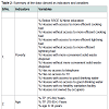
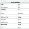
 The demographic datasets represent variables on spatial enumeration extent covering LGAs and include: population figures, gender and age distribution, housing conditions, family structure, marital status, disability figures and socio-economic variables. Data from the Lagos state digests of statistics and the Abstracts of Lagos state local government statistics are more refined in that they contain information on Local Council District Authorities (LCDA). Nevertheless, the data are not discrete enough to enable the assessment of vulnerability at that scale. However, national and Lagos state demographic datasets were carefully integrated and in addition to topography, a set of variables from which nine indicators of SocVI for the Lagos area were determined (see Table 2). These variables were selected based upon previous studies, such as: [44-46] and the authors’ local knowledge of the study area. The determined indicators are: poverty, marital status, age distribution, gender differences, housing condition, family structure, socio-economic, disability and topography.
 The present study has made some modifications to the existing methodology. The first modification is the inclusion of family structure which is represented as: the percentage of houses owned by head of family and the percentage number of houses owned by any other member of the family, the percentage number of people with relationship with the head of family. Such inclusions are based on the authors’ subjective judgement, as it is argued that a significant amount of the causes of vulnerability to flooding in Lagos, are due to the way the people live. It is argued that co-habitation tends to be an advantage in such areas, but it also constitutes considerable setback when weighed against recovery from losses after a sudden flood event. The capacity to cope and recover quicker from losses after the hazard is often developed by a mutual co-existence.
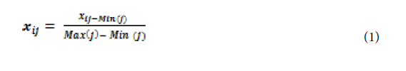
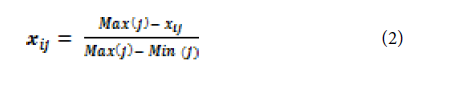
 Equations (1) and (2) below are two models for data normalization by HDI methodology, and are appropriate for positive and negative functional relationships respectively. By using the HDI methodology for normalization, it is possible to suppress the bias of weights assignment based on expert knowledge of the study area.
 A significant advantage of applying the Patnaik and Narayanan methodology is the possibility of knowing how each group of variables contributes to the overall vulnerability, which is simply an average of independent group scores. It is most suitable for the study due to the complexity in using other models, limited sample size, lack of data, and their possible issues of multicollinearity which may be present in the data to be modelled.
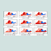
 To utilize fully the potential of the method used in the research, vulnerability based on each individual social component was mapped (Figure 3). These maps reveal variations of social vulnerability components across the spatial scales of Lagos. This is the main novelty of the present research which makes contribution to the science of flood risk management especially at identifying the demographic and socio-economic factors which influence vulnerability and how they are spatially distributed across a geographic unit.
Assessment of Social Vulnerability for Efficient Management of Urban Pluvial Flooding in the Lagos Metropolis of Nigeria
Ugonna C. Nkwunonwo*
- Department of Geoinformatics and Surveying, University of Nigeria, Enugu Campus, Nigeria
*Address for Correspondence: Ugonna C. Nkwunonwo, Department of Geoinformatics and Surveying, University of Nigeria, Enugu Campus, Nigeria, Tel: 07457000650; E-mail: ugonna.nkwunonwo@unn.edu.ng
Citation: Nkwunonwo UC. Assessment of Social Vulnerability for Efficient Management of Urban Pluvial Flooding in the Lagos Metropolis of Nigeria. J Environ Stud. 2017;3(1): 11.
Copyright © 2017 Nkwunonwo UC. This is an open access article distributed under the Creative Commons Attribution License, which permits unrestricted use, distribution, and reproduction in any medium, provided the original work is properly cited.
Journal of Environmental Studies | Volume: 3, Issue: 1
Submission: 23 January, 2017 | Accepted: 27 February, 2017 | Published: 03 March, 2017
Abstract
Flooding of pluvial origin has been pervasive in the Lagos area of Nigeria, and threatens significant human populations and urban assets, resulting in large scale economic losses. Unfortunately, investigating especially the human impacts of this hazard is often hampered by the dearth of quality datasets. This study was designed to construct indices of social vulnerability (SocVI) to pluvial urban flooding in the Lagos areas, using available demographic datasets. This will facilitate knowledge transfer and policy development towards mitigating the human impacts of flooding which is a crucial concern in environmental studies, earth sciences, disaster prevention and flood risk management research. Social vulnerability was conceptualised in terms of exposure, susceptibility and lack of coping capacity, whilst nine indicators were normalised, aggregated and ranked using combined UNDP’s Human Development Index and Patnaik and Narayana methodologies. Results reveal high indices of social vulnerability to pluvial flooding in three local government areas of Lagos - Alimoso, Agege and Kosofe. The study also identifies patterns of vulnerability based on individual social components. Gender variation, socio-economic status, and family structure were found to have significant impacts on the overall index. In addressing the challenges of pluvial urban flooding in Lagos, this study recommends prioritizing resources and intervention, especially in relation to building effective coping capacity in those areas that indicate higher social vulnerabilities to the hazard. This study, by constructing new SocVI, has demonstrated the potential in freely available datasets to investigate social vulnerability for Lagos.Keywords
Urban pluvial flooding; Lagos city; Social vulnerability; Coping capacity; Resilience; Flood management policyIntroduction
Flooding is the most widespread of all naturally-occurring hazards, which threaten society’s human and economic development [1,2]. The severity of its impact is compounded by sea level rise, rapid population growth, urbanization and increased rainfall frequency and intensity related to changes in climate distribution. Historically fluvial and coastal flooding events are well documented and studied [3,4]. However, flooding from pluvial events often overwhelms urban drainage facilities and soil infiltration capacity [5]. In many urban localities, for example the Lagos area of Nigeria, the incidences and extent of these urban floods have been pervasive, and are being attributed mainly to poor urban planning, rapid population growth, and a lack of urban facilities [6,7]. Although these events are being associated with large-scale economic impacts, astonishingly, efforts to tackle the challenge, to de-escalate especially the human impacts of this hazard appear to have been inadequate, whilst the potential for economic losses, along with vulnerabilities associated with social and demographic factors rises [8]. These issues are of grave research significance within the context of disaster prevention and management. In relation to a risk-based management of urban flooding, the extent to which different sections of the human population are exposed to pluvial urban flooding and the degree to which social factors are influencing vulnerabilities are crucial investigations.Unlike cities in the developed countries, the lack of quality datasets and difficulty in accessing available ones are major issues in Lagos. However, since increasing frequency and intensity of pluvial events are expected to worsen the occurrence of low probability flooding events in cities, considering the large human population and the lack of quality datasets, the need to develop flood risk mitigation measures using available resources is imperative. Therefore, the present research aims to assess social vulnerability in Lagos, Nigeria, to enable stake holders advance the goal of flood risk management in the area. The present method utilizes a part of the UNDP Human Development Index (HDI) approach and the Patnaik and Narayana [9] method to normalise, aggregate, and rank social vulnerability variables as well as to construct plausible indices. The key objective is to investigate the potential in currently available datasets to analyse social vulnerability, and to overcome the limitations in existing methods of vulnerability assessment.
Social Vulnerability
The concept of social vulnerability is extensively discussed in the literature relating to risk, hazard and the global environment [10,11]. It suggests the likelihood that losses will occur, although with considerations to social-economic and demographic factors, in time and space [12]. Birkmann held a view of this losses being as a result of a lack of social capacity to withstand stressors within the neighbourhood of a social systems [13], while Changnon suggested that the drivers of these losses are endogenous to the system, making the system susceptible to stressors [14]. In addition to susceptibility and a lack of coping capacity, social vulnerability is also defined on the basis of the degree to which a social system is exposed to a stressor [15-17]. Intuitively, these views, in a nutshell, clarify the fact that knowledge of social vulnerability and its analyses across various spatial and temporal scales is an essential part of disaster risk reduction (DRR),and this is promoted by the UNISDR risk management framework [18]. For an urban flood disaster, the knowledge of social vulnerability will assist a response team in delineating where the greatest social needs of a wider population are and in setting priorities for meeting them. Addressing these vulnerability odds will consequently mitigate human distress and the economic losses incurred following disaster recovery and reconstruction [19].Despite the usefulness of social vulnerability knowledge, progress in its assessment towards DRR is being constrained by the varied perspectives and their practical realisation considering data limitations [20-22]. The majority of approaches in the literature thrive on theoretical understanding of social vulnerability and its relationship with risk, utilise demographic datasets, and apply statistical modelling approaches [23-25]. With a lack of appropriate demographic data confronting many low-income societies, the ethos of these existing approaches is debunked by the choice of indicator which is fundamental to vulnerability analyses [23]. However, progress is still being made to formulate novel approaches that will rigorously address the increasing challenges of disasters. For example Ebert and Kerle assessed social vulnerability for Tegucigalpa, Honduras using object-oriented analysis of remote sensing and GIS data [26]. Zeng et al. applied a high resolution satellite image to assess social vulnerability in Guangzhou, South China [27]. Armaș and Gavris assessed social vulnerability for Bucharest, Romania using spatial multi-criteria analysis combined with the social vulnerability index [28]. Miao and Ding carried out a social vulnerability assessment of geological hazards based on entropy method in Lushan earthquakestricken area [29]. Bizimana et al. assessed the social vulnerability to malaria in Rwanda using a suite of statistical tools [30]. Similarly, the present research is a novel effort, which addresses the knowledge gaps in social vulnerability in Lagos, and constructs possible indices, despite the lack of quality data.
Description of Lagos Area of Nigeria, and an Overview of Pluvial Flooding in the Area
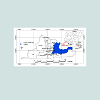
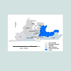
The Lagos coastal cityThe Lagos metropolis is a densely populated low-lying area on the south-western part of Nigeria, West Africa. The city, made up of sixteen Local Government Areas (LGAs), is encompassed within longitude 3.10E to 3.40E and latitude 6.50N to 6.80N (Figure 1). It has complex urban features, which include a dense network of roads and buildings, and several inland waterways and the Lagos Lagoon, which empties into the Atlantic. The conurbation serves as a major hub for transportation, tourism and economic activities in Nigeria, Africa and the rest of the world. Lagos is rated as the largest city in Nigeria (although the smallest land area), second largest in Africa and sixth largest in the world with present population estimated at over 20 million within a land area of about 1100 km2 (or 425 sq. miles) [31]. The population growth rate in the city is estimated to be 3.2% per annum, making Lagos a rapidly growing city [32]. The United Nations projects that Nigeria will be one of the eight countries expected to account collectively for half of the total population increase in the world from 2005-2050, and will by 2100, record a population amounting between 505 million and 1.03 billion people [33]. High population density is a major problem in the city, subjecting the area to lack of space for the myriad of human activities which often manifest itself in muddled human settlements, including overcrowding, slum and illegal developments, pollution, and other social and environmental disorder [8].
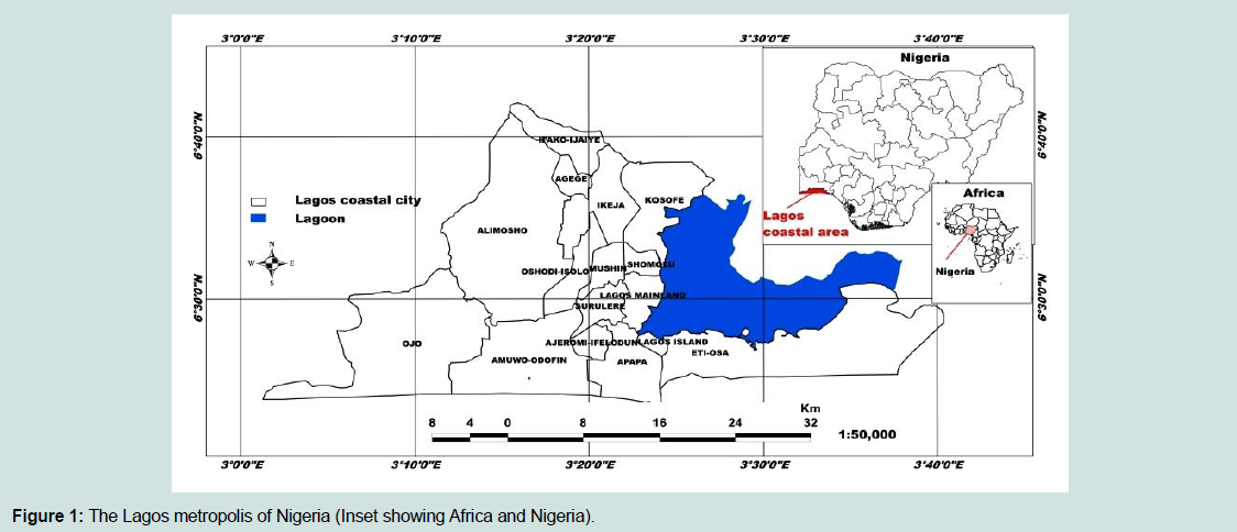
Figure 1: The Lagos metropolis of Nigeria (Inset showing Africa and Nigeria).
Pluvial flooding within Lagos is often an annual occurrence [34,35]. Whilst coastal and fluvial floods have often been recorded, flooding due to pluvial events has been more widespread in recent times and usually occurs between July and October (rainy season) with severe consequences mainly in Lagos Island, Apapa, Ikeja, Mushin, Surulere and parts of Ikorodu [36]. These floods affect many people, mainly through displacement, mortality, physical injuries, emotional disorders and spread of diseases. It also has severe impacts on economic activities and urban infrastructure. These impacts trigger concerns for environmental management, urban development, governance, vulnerability of urban residents, etc., [37-39]. The review of Lagos urban flooding in [8] presented a summary of major pluvial flooding events and associated threats, covering four decades. The 2011 July flooding caused by a severe storm that lasted 17 hours is a typical example. The flood affected many people with over 100 fatalities. There was also significant damage to public infrastructure including roads, bridges and schools with an estimated economic loss of about 50 billion Naira ($US 320 million) [40].
The likelihood that future population growth will increase the future human impacts of flooding highlights the need to give more attention to the issues of human vulnerability to urban flooding in the Lagos area. The assessment of social vulnerability to flooding in Lagos has arguably been inadequately assessed. Social vulnerability indices (abbreviated as SocVI in the present research), computed by the evaluation of how social factors relate with one another to produce the overall vulnerability is lacking. Within the global context, vulnerability assessment is an advanced concept in flood risk mitigation [41]. In the Lagos area itself, Adelekan, Olajuyigbe et al., Ajibade et al. and Nkwunonwo et al. considered vulnerability within their research but often in a more localized context [36,37,42,43]. Research to date has arguably lacked the element of “wider application” required for social and political links necessary to take advantage of resources that would accelerate recovery for populations socially vulnerable to all types of natural hazards. Ajibade et al. assessed social vulnerability to flooding in the area, but focused attention on gender [37]. Whereas it can be recognized that gender is a key consideration in matters relating to social vulnerability, it is argued that dealing with it in isolation lacks the substance to reveal the pattern of vulnerability in an area. In those studies, the problem of data limitation was raised but not discussed. The means to obtain and utilize freely availabledata to assess vulnerability indices remains both a promising and a challenging issue. The data available must be good enough to give a measure of reliability in flood risks mitigation. Attempting to address this situation, Ajibade et al. utilized demographic data, in addition to primary survey to adapt proven methodologies to local situations [37]. Nevertheless, the research only addressed gender aspect of social vulnerability, whilst other demographic and socio-economic components that influence vulnerability in Lagos remain unknown.
The limited focus on the assessment of vulnerability to pluvial flooding in the Lagos and the limited scope and application of the few existing studies create a potential gap in knowledge in flood risk mitigation in the area. Lagos is one of the places that do not have good quality datasets to represent indicators of social vulnerability. Although the 2006 national demographic dataset and data from the Lagos state digest of statistics are available, but they are not detailed. Whilst social vulnerability constructs are often based on data at ward levels, the data for Lagos area are available at LGA and Local Council Development Authority (LCDA) levels and at these levels, information on social variables is generalised. However, the focus and working theory of the present research is to construct a realistic SocVI despite the scale of available datasets. The need to construct an index of social vulnerability to support policy towards flood risk mitigation remains serious. The roles such an index will play towards defining the susceptibilities and the lack of coping capacity of different people and places to the hazard as well as building a society more resilient towards urban flooding are clear, and highlight the significance of the present research.
Method and Data
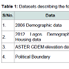
The present study ranks the 16 LGAs of the Lagos coastal area with respect to susceptibility, exposure and lack of coping capacity to urban flooding, using demographic data (obtained from 2006 Nigerian national demographic and housing census, 2012 Lagos state digest of statistics and 2012 Abstracts of Lagos state local government statistics). Other relevant datasets are 30 m horizontal resolution and 20 m vertical accuracy ASTER GDEM and political boundary of the Lagos, Nigeria in vector format. These datasets (described in Table 1) were selected based on their availability and relevance with respect to the study area. It should be recognised that these data sets have been used to demonstrate an approach that could be adopted in data sparse urban areas.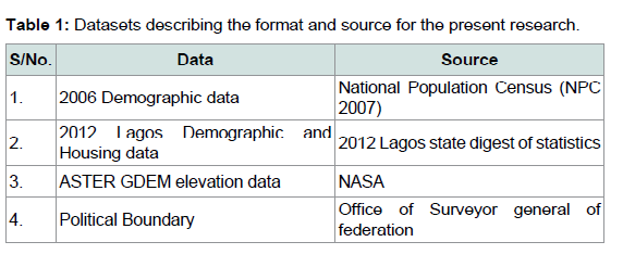
Table 1: Datasets describing the format and source for the present research.
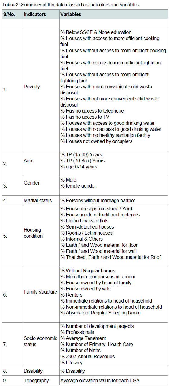
Table 2: Summary of the data classed as indicators and variables.
In order to make the vulnerability assessment exclusive to flood hazard, the next modification was the inclusion of topographic information to the variables for computation of SocVI. As a result of the spatial extent of the domain being considered (i.e. LGAs), the average elevation for each of the constituting LGAs was extrapolated, supposing that vulnerability to flooding relates to relative differences in elevation since flooding in the study area is also aided by flat topography. This is particularly important for handling uncertainty due to the absence of a flood hazard map and the lack of information to describe the drainage systems.
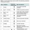
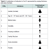
The collected data were tabulated in MS-EXCEL 2010 spreadsheet in the form of a regular matrix, with the columns representing the indicators, and the rows representing the variables for the 16 LGAs of the Lagos metropolis. Excel 2010 spreadsheet was chosen for this present research because of the availability of much mathematical functions and the flexibility to create newer ones to run the vulnerability model. This research adopted part of the methodology used in UNDP’s Human Development Index (HDI) [47] to normalize the datasets of various units and scales, and to combine them to derive various grouped sources of vulnerability. HDI method presupposes that a functional relationship of the values with vulnerability should be known. This is simply how each variable within the datasets contribute to social vulnerability, either positively or negatively. The negative contribution decreases vulnerability and is indicated with a downward arrow. On the contrary, a positive contribution increases vulnerability, and is shown as an upward arrow (Table 3 summarizes the functional relationships of the indicators and the main assumptions underlying them).
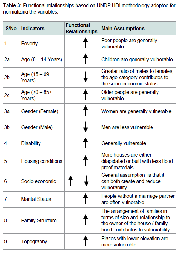
Table 3: Functional relationships based on UNDP HDI methodology adopted fornormalizing the variables.
xij is the value of ith row and jth column of the variable table, Max (j), and Min (j) are the maximum and minimum values in the jth column.
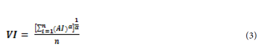
The normalized components of vulnerabilities were aggregated and ranked using the method of aggregating in [9] which applies simple averaging. Patnaik and Narayanan proposed equation (3) below for use in aggregating the group variables and ranking the resulting vulnerability scores. In using this method, the standardized variables for each indicator were aggregated by simple averaging to obtain a discrete vulnerability (AI) for each indicator. For those indicators such as marital status, disability and topography having single variable, their discrete vulnerabilities were taken as the normalized values. The outcome of this operation is shown in Table 4.
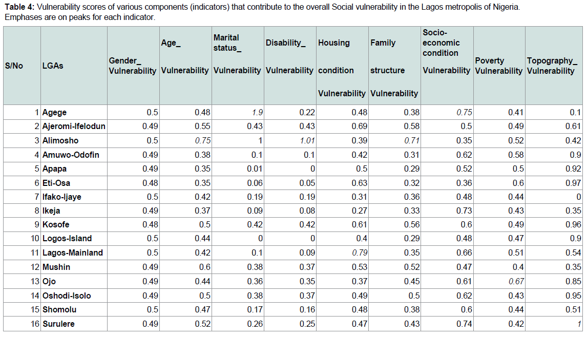
Table 4: Vulnerability scores of various components (indicators) that contribute to the overall Social vulnerability in the Lagos metropolis of Nigeria. Emphases are on peaks for each indicator.
VI is the vulnerability index, AI is the vulnerabilities of the components, n represents the number of sources of vulnerability, and α is equal to n.
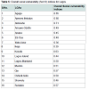
The overall SocVI based on the discrete vulnerabilities of the indicators were obtained from equation (3) by putting the discrete vulnerabilities into an additive model and dividing the outcome by the number of indicators considered, in this case nine. The number of indicators does not affect the outcome of the SocVI as long as the functional relationships of the variables were accurately determined and applied at the normalization stage. This operation is repeated for all the constituting LGAs. Then the outcome is ranked beginning with the LGAs with the highest SocVI down to the lowest. The outcome is shown in Table 5 which delineates the overall SocVI for the sixteen LGAs of the Lagos area with Alimosho, Agege and Kosofe LGAs at extreme social vulnerability to urban flooding in Lagos.
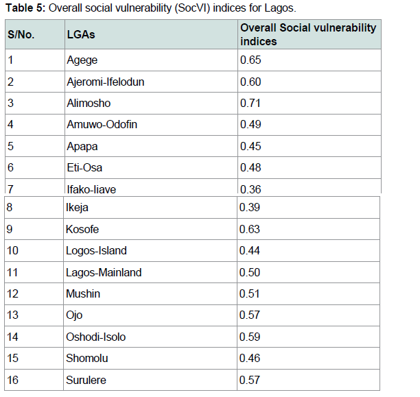
Table 5: Overall social vulnerability (SocVI) indices for Lagos.
For the final mapping and visualization of the indices of social vulnerability, ESRI ArcGIS 10.1 software was used, chosen because of the versatility and availability of many geospatial analysis tools. The attribute table containing the indices of social vulnerability of the Lagos and the spatial database were linked to create a vector map delineating the indices of social vulnerability. The resulting map was symbolized using graduated colour scheme based on quantiles to create five classes, ranging from less vulnerable classes to highly vulnerable classes of social vulnerabilities. The use of graduated schemes as against graded colours (low to high) was necessary in order to differentiate between the LGAs in respect of their social vulnerabilities which is important consideration of this study. Figure 2 is the map of social vulnerability indices for the sixteen LGAs that formed the Lagos area of Nigeria. The outcome of this map is confirmed by a previous investigation in [48] which identified Kosofe LGA as highly vulnerable area to urban flooding in Lagos.
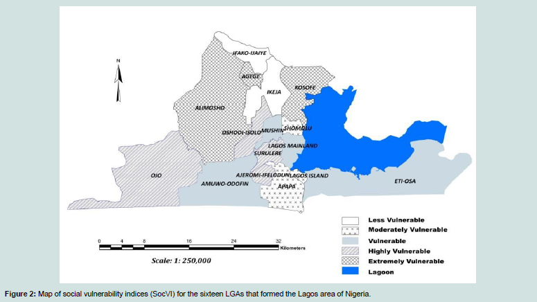
Figure 2: Map of social vulnerability indices (SocVI) for the sixteen LGAs that formed the Lagos area of Nigeria.

Figure 3: Map of the sixteen LGAs of Lagos area of Nigeria, based on each individual component of social vulnerability
Results and Discussions
Overall, the social vulnerability assessment carried out in this research reveals three LGAs in the Lagos area that are classed as extremely vulnerable to urban flooding. Four LGAs were found to be highly vulnerable, whilst the remaining LGAs are classed as follows: four LGAs are relatively vulnerable, three are moderately vulnerable and the remaining two are less vulnerable. Alimosho, Agege, Kosofe, Ojo, Surulere, Ajeromi-Ifeledun and Oshodi-Isolo LGAs are the highly vulnerable areas while Ifako-Ijaiye and Ikeja LGAs are the less vulnerable ones. Apapa, Lagos Island and Shomolu LGAs are vulnerable, but not comparable to Eti-osa, Lagos mainland and Amuwo-Odofin LGAs (see Figure 2).Additionally, the vulnerabilities based on each of the demographic and socio-economic variable are also shown (Figure 3). These maps show that Alimosho along with Agege, Ifako-Ijaiye, Lagos-Island, Lagos-mainland, and Shomolu LGAs may be ranked as highly vulnerable in term of gender variations. This is because of the extensive female population in the area. Data from the National Population Commission shows that more than 8% of the total women in the Lagos area reside in Alimosho LGA [49]. Compared to other LGAs where there are only about 3% at most, key factors in Lagos such as poverty, early marriage, and child care, limited education and financial opportunities which seem to subject mainly women to social vulnerability are more pervasive in Alimosho. Alimosho LGA is also most highly ranked in terms of age differences, marital status, disability and family structure. Age factors apples mostly to elderly people in the present research, although children aged 0-14 were also considered. Because of the large population in Lagos, there are many elderly people who are dependants of other younger residents in the area. Care for elderly people is a critical issue in Nigeria, and this reflects the situation of elderly population in Lagos, whilst there are limited well established elderly peoples’ hospices [50]. To cope with this situation, the majority of elderly population reside with relatives and friends, and such co-habitation with no reasonably enhanced economic potential and opportunity can constitute a major source of social vulnerability in Alimosho LGA.
Lagos mainland, Surulere and OJo LGAs are ranked highly vulnerable in terms of housing condition, socio-economic status and poverty respectively. A clear picture of Lagos shows that the great deal of slum development in Alimosho is arguably some overly anthropogenic measure to cope with limited housing in Lagos. With regards to socio-economic status housing condition, poverty and family structure, these measures escalate the social vulnerability of residents in the areas affected. For example, family structure, which is in this research, is explained by the relationship that exits among the members of a household, underlines a complicated situation in Alimosho LGA. Similar to many places in Nigeria, most houses in the Lagos are rented, whilst the relationship existing between the house owners and tenant is purely on business grounds [49,51]. The ability to cope with losses under such situation is often restricted since there is lack of mutual cooperation and support. This tickles down to the fate of disabled persons (especially in Alimosho where it is a major source of social vulnerability) who both lack the sufficient physical capacity and economic means to adapt to various situations at various times. Nkwunonwo et al. argued that disability remains a poorly managed situation due to the poor political will power, and weak institutional capacity that plague Nigeria and undermine the formulation and implementation of robust social and economic policies [43]. This is a major issue of social vulnerability which highlight the importance of the present research and in terms of identifying the specific areas in the Lagos metropolis where key shoulders need to prioritize attention towards building social capacities.
The role played by topography as proxy to flood hazard in the study area is validated, given that the highly vulnerable LGAs (Alimosho, Agege Kosofe and Surulere LGAs) appear to be lower in elevation. Using the ASTER GDEM dataset, the lowest elevation in the Lagos area (which is 16 m) was found to in Surulere, and this provides undisputable in validation for the highly social vulnerability index in the area. Elevation data of a much higher quality is often recommended in any study related to flood risk assessment. However, for this study, such high quality data set was not available to the authors. Although the use of elevation data was informed by the lack of a suitably convenient proxy for urban flooding, the results correlate well with the hypothesis that elevation differences which dictate the flow of pluvial floods within spatial and temporal scales can provide a convenient factor for modelling social vulnerability to urban flooding in Lagos. Following this hypothesis, it is important to understand the contribution (or strength) of each of variables to the overall SocVI. Thus, a simple regression analysis can be used to investigate this relationship. The results of such analysis (without topography: see Tables 6 and 7) firstly suggest the indicators are statistically significant, explaining up to 97% of the total variances in the SocVI. Then, it shows the strongest contributing indicators to the overall SocVI are gender, socio-economic condition and poverty, while family structure age and disability contribute minimally. However, the high vulnerability indices shown by the highly vulnerable LGAs may be attributed to the combination of dominant indicators of the component vulnerabilities in those areas, and these are: age distribution, marital status, disability, family structure and socioeconomic condition. These indicators seem to suggest susceptibility and serious lack of coping capacity to urban flooding in the area. How these dominant indicators (which are diagrammatically shown in Table 8) influence social vulnerability to pluvial flooding in the Lagos area is discussed in [43].
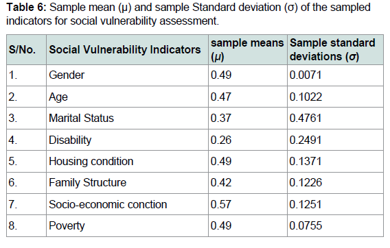
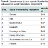
Table 6: Sample mean (μ) and sample Standard deviation (σ) of the sampledindicators for social vulnerability assessment.
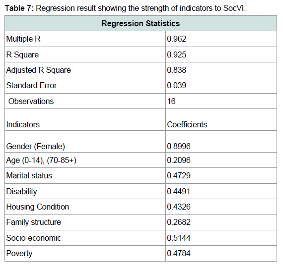
Table 7: Regression result showing the strength of indicators to SocVI.
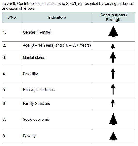
Table 8: Contributions of indicators to SocVI, represented by varying thickness and sizes of arrows.
SocVI may be construed as a compromise in social vulnerability assessment prompted by lack of consistent set of metrics for assessing social vulnerability [13]. Although an index such as this is typically a number, the issue of how it is computed remains heterogeneous over the years, and has received considerable attention. Regardless of research philosophy (qualitative or quantitative), a significant challenge facing the task of constructing the SocVI is choice of/ selection of indicators, an issue which the present research attempts to overcome. In [44] and [52], the United States Census Bureau data have been utilized to inductively compute SocVI. These studies determined social vulnerabilities based on such indicators as poverty, age, gender, race, ethnicity, disability (to represent various components underlying the framework of social vulnerability being adopted) and have been adopted by a number of other studies [see for examples: 37,45,53-55]. Although these approaches are being standardised, the paucity of good quality dataset to represent these indicators, especially in places without national database of social variables, is a major limitation. Moreover, the methods used in these studies required that input data have to be analysed for some properties which tend to undermine the results of social vulnerability computations, for examples multicollinearity (tendency to correlate too highly) and singularity (tendency to measure essentially the same theme).
The absence of a standard for the choice of input data for constructing SocVI leaves the researcher with an option of finding a way to either thin the acquired data or aggregate them. In many previous studies (for examples, [56] and [21]), a practical approach to this challenge was implementing a factor analysis (FA) to reduce a large sample of a dataset to a more manageable number, whilst still retaining their central theme. In Cutter et al. and Abson et al. the authors applied the principal component analysis (PCA) to achieve the purpose of dataset reduction [44,57]. Both approaches (FA/PCA), adopted by the authors above seem to share a similar aim of thinning a large sample of data, identifying and extracting factors that explained most of the variations in the acquired datasets. Whilst equally being preferred to subjective decision to create a weighting scheme, PCA/FA produces results of social vulnerability index that compares well with observed field data.
Although the application of PCA/FA to the computation of social vulnerability index seems more plausible with regards to results of vulnerability analyses, does always give an idea of the major theme that a cluster of variables is measuring and explains the communalities in the variables, it requires a number of stringent considerations. First, the sample size must be reasonable enough, say at least 10-15 participants per variable, as shown in [58]. This makes the application of PCA/FA to analysis involving an area of few districts, for example the sixteen Local Government Area (LGAs) in the Lagos coastal city, over very large variables difficult. Running the model requires knowledge of the mathematics of orthogonal projection and Eigen values and eigenvector simplifications (a case that resides within engineering and most earth sciences). It is equally important to have a good knowledge of statistics to be able to run such PCA/FA models. To overcome these limitations, the present research has proposed and implemented an efficient method to assess the vulnerabilities of social systems to urban flooding in Lagos. The new method, which utilizes a part of the UNDP Human Development Index (HDI) approach and the Patnaik and Narayana method to normalise, aggregate, and rank vulnerability indices is the first published attempt to rank social vulnerability for the LGAs that form Lagos area [9].
The method described in the present research is based on specific issues relating to social vulnerability to Lagos urban flooding [59]. Such issues as family structure, peculiar gender variations, and settlement pattern have been exploited, to construct the Lagos SocVI. Key features of this method are: (1) Simple modifications based on location-specific issues, (2) modularity, in which specific vulnerabilities are computed based on individual social variables, and (3) sparse-data sensitivity.
Conclusion
Pluvial flooding events have been traumatic in the Lagos area of Nigeria, and the question of how to assist human populations to reduce their susceptibilities and develop capacities to cope with such increasing hazard requires more attention. With respect to recent integrated approaches to flood risk mitigation by United Nation International Strategy on Disaster Reduction (UNISDR) and Climate Change Adaptation (CCA) methodologies, the way-forward arguably involves assessment of vulnerability. In this regard, social vulnerability is for the most part considered since it takes social characteristics, such as age variation, gender differences, socioeconomic status, etc., to compute indices which generally explain the extents and variation to which coastal human populations are easily affected by flood hazard. Such characteristics dynamically relate to disaster risk losses and generally drive focus on human beings. Whist a lack of data about social characteristics constrains efforts towards computing more accurate social vulnerability indices (SocVI), freely available data can be utilized to an approximate counterpart that can serve immediate purposes.SocVI for the 16 Local Government Areas (LGAs) of the Lagos metropolis has been computed in this study by utilizing demographic data from Nigeria Population Commission, Lagos state digest of statistic and abstract of Lagos local government statistics along with elevation values extrapolated from Advanced Space-borne Thermal Emission and Reflection Radiometer Global Digital Elevation Model (ASTER GDEM). The inclusion of elevation values was necessary to make the indices exclusive to flood hazard. Carefully selected variables were normalized by means of a part the UNDP human development Index methodology (HDI). To deal with the challenge of equal weighting which would suggest that the indicators contribute equally to the overall social vulnerability, the study applies the method proposed by Patnaik and Narayanan (2009) to aggregate and rank the indicators. In the end, with the exception of topography which served as proxy for flood hazard, there were eight different indicators, which whilst showing different strengths to the overall SocVI, suggest a tendency towards susceptibility and a lack of capacity to cope with flood hazard. Besides the final mapping of the SocVI in a Geographic Information System (GIS), some statistics were run along with a simple linear regression analysis to further explore the indicators with respect to their ranges of contribution to the overall SocVI.
In view of social vulnerability assessment for the Lagos area, the study reveals three LGAs (Agege, Alimosho and Kosofe) as very highly vulnerable to flood hazard. Other LGAs are also delineated. The high vulnerability indices shown by the some of the LGAs are as a result of their high scores in five of the indicators which are: age distribution, marital status, disability, family structure and social-economic status. While there is a great deal of slum development in the Lagos area, disability remains a poorly managed situation. The study further reveals the ability to cope with flood hazard is also compromised by poor socio-economic status, gender variations, poverty and housing condition, which also played considerable roles in the overall SocVI.
One major issue that requires immediate attention with regards to future study is dataset quality. The demographic data that were utilized in the study lack detailed spatial resolution. This also applies to the elevation data used for flood risk assessment. A more detailed demographic data would be able to improve the quality of the SocVI, as well as clarify the assumption made about the flood hazard, which was represented by means of elevation. The elevation data applied was of a 30 m spatial resolution, which previous studies have identified to overestimate inundation extent during flood modelling. It is also recommended that a study which integrates these results with flood hazard simulated by means of hydraulic models be carried out. This will be necessary to validate the results which the authors do not have the resources to undertake at this stage. It is also recommended for future studies that the application of land use scenarios for sensitivity analysis of the indices, and the need to define the uncertainty in the output. While the results obtained from the study can serve as working document towards mitigating the loss of lives and properties, as well as disruption of human and economic activities during flooding events in the area, it could also be useful for decision making and prioritizing plans and strategies with regards to building effective coping capacity in those areas with higher susceptibility to the flood hazard.
Acknowledgements
This publication reports findings of a PhD research, which was funded by the Tertiary Institutions Education Trust Fund (TETFund) programme, a federal government-university of Nigeria academic staff intervention scheme. The Surveyors Council of Nigeria (SURCON) is acknowledged for providing some supplementary grants. Data relating to the social variables were sourced mainly from the Nigerian Population Commission and the Lagos state digest of Statistics. Previous works in the area of social vulnerability assessment, especially the original work of Professor Suzan Cutter, Patnaik and Narayana, among others are equally acknowledged, and so are the anonymous reviewers, and the editor of this article.References
- Messner F, Meyer V (2006) Flood damage, vulnerability and risk perception-challenges for flood damage research. In: Schanze J, Zeman E, Marsalek (Eds), Flood risk management: hazards, vulnerability and mitigation measures. Springer, Netherlands, pp. 149-167.
- Nwilo PC, Olayinka DN, Adzandeh AE (2012) Flood modeling and vulnerability assessment of settlements in the Adamawa state floodplain using Remote Sensing and Cellular Framework Approach. Global J Human Soc Sci 12: 10-20.
- Merz B, Kreibich H, Schwarze R, Thieken A (2010) Assessment of economic flood damage. Nat Hazards Earth Syst Sci 10: 1697-1724.
- Penning‐Rowsell EC (2014) A realistic assessment of fluvial and coastal flood risk in England and Wales. Trans Inst Br Geogr 40: 44-61.
- Huong HT, Pathirana A (2013) Urbanization and climate change impacts on future urban flooding in Can Tho city, Vietnam. Hydrol Earth Syst Sci 17: 379-394.
- Adelekan IO (2015) Flood risk management in the coastal city of Lagos, Nigeria. J Flood Risk Manag 9: 255-264.
- Adeloye AJ, Rustum R (2011) Lagos (Nigeria) flooding and influence of urban planning. Proc Inst Civ Eng Urban Des Plan 164: 175-187.
- Nkwunonwo UC, Whitworth M, Baily B (2016) Review article: A review and critical analysis of the efforts towards urban flood risk management in the Lagos region of Nigeria. Nat Hazards Earth Syst Sci 16: 349-369.
- Patnaik U, Narayanan K (2009) Vulnerability and climate Change: An analysis of the Eastern Coastal Districts of India. Munich Personal RePEc Archive (MPRA).
- De Lange HJ, Sala S, Vighi M, Faber JH (2010) Ecological vulnerability in risk assessment-a review and perspectives. Sci Total Environ 408: 3871-3879.
- Tucker J, Daoud M, Oates N, Few R, Conway D, et al. (2015) Social vulnerability in three high-poverty climate change hot spots: What does the climate change literature tell us? Reg Environ Change 15: 783-800.
- Cutter SL, Barnes L, Berry M, Burton C, Evans E, et al. (2008) A place-based model for understanding community resilience to natrural disasters. Global Environ Change 18: 598-606.
- Birkmann J (2006) Measuring vulnerability to promote disaster-resilient societies: conceptual frameworks and definitions. In: Birkmann J (Ed), Measuring vulnerability to natural hazards: towards disaster resilient societies. United Nations University Press, Tokyo, pp. 9-54.
- Changnon SA (2005) The 1993 Flood's aftermath: risks, root causes and lessons for the future. J Contemp Water Res Educ 103: 70-74.
- Cardona OD, van Aalst MK, Birkmann J, Fordham M, McGregor G, et al. (2012) Determinants of risk: exposure and vulnerability. In: Field CB, Barros V, Stocker TF, Qin D, Dokken DJ, et al. (Eds), Managing the risks of extreme events and disasters to advance climate change adaptation. Special Report of the Intergovernmental Panel on Climate Change (IPCC). Cambridge University Press, Cambridge, UK, pp. 65-108.
- Norris FH, Stevens SP, Pfefferbaum B, Wyche KF, Pfefferbaum RL (2008) Community resilience as a metaphor, theory, set of capacities, and strategy for disaster readiness. Am J Community Psychol 14: 127-150.
- O'Brien K, Leichenko R, Kelkar U, Venema H, Aandahl G, et al. (2004) Mapping vulnerability to multiple stressors: climate change and globalization in India. Global Environ Change 14: 303-313.
- UNISDR (2010) Making cities resilient: my city is getting ready: World Disaster Reduction Campaign 2010-2011. United Nations International Strategy for Disaster Reduction.
- Flanagan BE, Gregory EW, Hallisey EJ, Heitgerd JL, Lewis B (2011) A social vulnerability index for disaster management. J Homeland Security Emerg Manag 8: 1-24.
- Hogan DJ, Marandola E Jr (2005) Towards an interdisciplinary conceptualisation of vulnerability", Population Space Place 11: 455-471.
- Schmidtlein MC, Deutsch RC, Piegorsch WW, Cutter SL (2008) A sensitivity analysis of the social vulnerability index. Risk Anal 28: 1099-1114.
- Tapsell S, McCarthy S, Faulkner H, Alexander M (2010) Social vulnerability to natural hazards. CapHaz-Net’s WP4 report from, Flood Hazard Research center- FHRC, Middlesex University, London.
- Birkmann J (2007) Risk and vulnerability indicators at different scales: applicability, usefulnesss and policy implications. Environ Hazards 7: 20-31.
- Ebert A, Kerle N, Stein A (2009) Urban social vulnerability assessment with physical proxies and spatial metrics derived from air-and spaceborne imagery and GIS data. Nat Hazards 48: 275-294.
- Yoon DK (2012) Assessment of social vulnerability to natural disasters: a comparative study. Nat Hazards 63: 823-843.
- Ebert A, Kerle N (2008) Urban social vulnerability assessment using object-oriented analysis of remote sensing and GIS data. A case study for Tegucigalpa, Honduras. Int Arch Photogramm Remote Sens Spat Inf Sci 37: 1307-1312.
- Zeng J, Zhu ZY, Zhang JL, Ouyang TP, Qiu SF, et al. (2012) Social vulnerability assessment of natural hazards on county-scale using high spatial resolution satellite imagery: a case study in the Luogang district of Guangzhou, South China. Environ Earth Sci 65: 173-182.
- Armaș I, Gavriș A (2013) Social vulnerability assessment using spatial multi-criteria analysis (SEVI model) and the Social Vulnerability Index (SoVI model)- a case study for Bucharest, Romania. Nat Hazards Earth SystSci 13: 1481-1499.
- Miao C, Ding M (2015) Social vulnerability assessment of geological hazards based on entropy method in Lushan earthquake-stricken area. Arab J Geosci 8: 10241-10253.
- Bizimana JP, Twarabamenye E, Kienberger S (2015) Assessing the social vulnerability to malaria in Rwanda. Malaria J 14: 1-21.
- Lagos State Government (LSG) (2012) Abstract of Local Government Statistics Lagos. Lagos Bereau of Statistics, Ministry of Economic Planning and Budget Secretariat, Alausa, Ikeja.
- World Bank (2013) Working for a world free of poverty, Population. Working paper, Washington, DC: World Bank Group.
- United Nations (2004) World Population to 2300, working paper, New York: United Nations Department ofEconomic and Social Affairs, Population Division.
- Etuonovbe AK (2011) The devastating effect of flooding in Nigeria - Angela Kesiena ETUONOVBE, Nigeria.
- Odunuga S (2008) Urban land use change and the flooding in Ashimowu watershed, Lagos, Nigeria. University of Lagos, Nigeria.
- Olajuyigbe AE, Rotowa OO, Durojaye E (2012) An assessment of flood hazard in Nigeria: the case of mile 12, Lagos. Mediterranean J Soc Sci 3: 367-375.
- Ajibade I, McBean G, Bezner-Kerr R (2013) Urban flooding in Lagos, Nigeria: Patterns of vulnerability and resilience among women. Global Environ Change 23: 1714-1725.
- Lamond J, Stanton-Geddes Z, Bloch R, Proverbs D (2013) Cities and flooding: Lessons in resilience from case studies of integrated urban flood risk management. In: CIB 2013 World Congress (Ed), Special Conference Session: Making Cities More Resilient, Brisbane, Australia, 5-9 May 2013. Brisbane: CIB.
- Soneye A (2014) An overview of humanitarian relief supply chains for victims of perennial flood disasters in Lagos, Nigeria (2010-2012). J Humanitarian Logistics Supply Chain Manag 4: 179-197.
- Oladunjoye M (2011) Nigeria: July 10 flooding - Lagos gives relief materials to victims. Daily Champion Newspaper.
- Kaźmierczak A, Cavan G (2011) Surface water flooding risk to urban communities: Analysis of vulnerability, hazard and exposure. Landsc Urban Plan 103: 185-197.
- Adelekan IO (2010) Vulnerability of poor urban coastal communities to flooding in Lagos, Nigeria. Environ Urban 22: 433-450.
- Nkwunonwo UC, Whitworth M, Baily B (2015) Relevance of social vulnerability assessment to flood risk reduction in the Lagos metropolis of Nigeria. Br J Appl Sci Technol 8: 366-382.
- Cutter SL, Boruff BJ, Shirley WL (2003) Social vulnerability to emvironmental hazards. Soc Sci Q 84: 242-261.
- Rygel L, O'Sullivan D, Yarnal B (2006) A Method for constructing a social vulnerability index: an application to hurricane storm surges in a developed country. Mitigation Adapt Strateg Glob Chang 11: 741-764.
- Zhang YL, You WJ (2014) Social vulnerability to floods: a case study of Huaihe River Basin. Nat Hazards 71: 2113-2125.
- UNDP (2006) Human development report, United Nations Development Program.
- Oyinloye M, Olamiju I, Adekemi O (2013) Environmental impacts of flooding on Kosofe local government area of Lagos state, Nigeria: A GIS perspective. J Environ Earth Sci 3: 57-66.
- National Population Commission (NPC) (2007) 2006 Population and housing census: National and State Population and Housing Tables: Priority Tables I-IV. FCT, Abuja: Federal Government of Nigeria, 10 October.
- Uwakwe R, Ibeh CC, Modebe AI, Bo E, Ezeama N, et al. (2009) The epidemiology of dependence in older people in Nigeria: prevalence, determinants, informal care, and health service utilization. A 10/66 dementia research group cross‐sectional survey. J Am Geriatr Soc 57: 1620-1627.
- Oladapo AA (2006) A study of tenants’ maintenance awareness, responsibility and satisfaction in institutional housing in Nigeria. Int J Strateg Prop M 10: 217-231.
- Wu SY, Yarnal B, Fisher A ( 2002) Vulnerability of coastal communities to sea-level rise: a case study of Cape May County, New Jersey, USA. Clim Res 22: 255-270.
- Akukwe TI, Ogbodo C (2015) Spatial analysis of vulnerability to flooding in port harcourt metropolis, Nigeria. Sage Open 5: 1-19.
- Alwang J, Siegel PB, Jørgensen SL (2001) Vulnerability: A view from different disciplines. The World Bank, Washington, DC.
- IPCC (Intergovernmental Panel on Climate Change) (2007) Climate change: Impacts, adaptation and vulnerability. Contribution of Working Group II to the Fourth Assessment Report of the Intergovernmental Panel on Climate Change. Cambridge University Press.
- Holand IS, Lujala P, Rød JK (2011) Social vulnerability assessment for Norway: a quantitative approach. Nor J Geogr 65: 1-17.
- Abson DJ, Dougill AJ, Stringer LC (2012) Using principal component analysis for information-rich socio-ecological vulnerability mapping in Southern Africa. Appl Geogr 35: 515-524.
- Field A (2006) Exploratory factor analysis. In: Field A (Ed). Discovering statistics using SPSS, Sage Publishers, London, pp. 617-680.
- Kuhlicke C, Scolobig A, Tapsell S, Steinführer A, Marchi BD (2011) Contextualizing social vulnerability: findings from case studies across Europe. Nat Hazards 58: 789-810.